Park nearby Stone Nullah Lane Garden
Hong Kong
Park nearby Stone Nullah Lane Garden
Stone Nullah Lane Garden
Wan Chai, Hong Kong
contacts phone
:
+852
Latitude:
22.272953
, Longitude:
114.173471
larger map & directions
read more
nearest Park
83 m
Kennedy Street Sitting-out Area
Near junction of, Kennedy Street
Park
read more
227 m
Jockey Club Park
Queen's Road East
Park
read more
258 m
Spring Garden Lane Sitting-Out Area
Hongkong
Park
read more
279 m
賽馬會復康花園
Wan Chai
Park
read more
286 m
5/F 平台花園
44-50 Lee Tung Street, Wan Chai
Park
read more
291 m
Yan Hui 5th Floor # Public Space
44-56 Lee Tung Street, Wan Chai
Park
read more
340 m
五樓平台花園,利東街公共空間
5/F, 30號 Amoy Street, Wan Chai
Park
read more
344 m
Stubbs Road Children's Playground
Hong Kong
Park
read more
349 m
利東街公共空間
5/F, 30號 Amoy Street, Wan Chai
Park
read more
358 m
寶雲道公園
Mid-level
Park
read more
363 m
Bowen Road Park
Mid-level
Park
read more
373 m
Tai Wo Street Playground
Tai Wo Street, Wan Chai
Park
read more
407 m
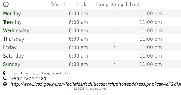
Wan Chai Park
Cross Lane, Wan Chai
Park
read more
439 m
Ship Street Playground
Wan Chai
Park
read more
463 m
Tung Wah Centenary Square Garden
Queen's Road East
Park
read more
505 m
Bauhinia Garden
Wan Chai
Park
read more
644 m
灣仔峽道休憩處
Wan Chai Green Trail, The Peak
Park
read more
675 m
Morrison Hill Road Playground
Oi Kwan Road, Morrison Hill
Park
read more
726 m
Fleming Road Garden
108 Gloucester Road, Wan Chai
Park
read more
779 m
Bowen Road Park
Hong Kong
Park
read more
785 m
Wan Chai Gap Park
27 Coombe Road, The Peak
Park
read more
888 m
Shui on centre Amarzaya
8 Harbour Road, Wan Chai
Park
read more
904 m
體育道花園
Happy Valley
Park
read more
928 m
香港藝術中心西公園(香港君悅酒店側)
號, 1 Harbour Road, Wan Chai
Park
read more
933 m
Happy Valley Playground
Happy Valley
Park
read more
📑
all categories
Accounting
Administrative area level 1
Administrative area level 2
Airport
Amusement park
Aquarium
Art gallery
Atm
Bakery
Bank
Bar
Beauty salon
Bicycle store
Book store
Bowling alley
Bus station
Cafe
Campground
Car dealer
Car rental
Car repair
Car wash
Casino
Cemetery
Church
City hall
Clothing store
Colloquial area
Convenience store
Courthouse
Dentist
Department store
Doctor
Electrician
Electronics store
Embassy
Establishment
Finance
Fire station
Florist
Food
Funeral home
Furniture store
Gas station
General contractor
Grocery or supermarket
Gym
Hair care
Hardware store
Health
Hindu Temple
Home goods store
Hospital
Insurance agency
Jewelry store
Laundry
Lawyer
Library
Light rail station
Liquor store
Local government office
Locality
Locksmith
Lodging
Meal delivery
Meal takeaway
Mosque
Movie rental
Movie theater
Moving company
Museum
Natural feature
Neighborhood
Night club
Painter
Park
Parking
Pet store
Pharmacy
Physiotherapist
Place of worship
Plumber
Point of interest
Police
Post office
Premise
Real estate agency
Restaurant
Roofing contractor
Route
Rv park, camping
School
Shoe store
Shopping mall
Spa
Stadium
Storage
Store
Subway station
Supermarket
Synagogue
Taxi stand
Train station
Transit station
Travel agency
University
Veterinary care
Zoo
↑