Park nearby Happy Valley Playground
Hong Kong
Park nearby Happy Valley Playground
Happy Valley Playground
Happy Valley, Hong Kong
contacts phone
:
+852
Latitude:
22.272961
, Longitude:
114.182538
larger map & directions
read more
nearest Park
230 m
Happy Valley Recreation Ground
1 Sports Road, Happy Valley
Park
read more
231 m
Leighton Hill Public Garden
Leighton Hill
Park
read more
301 m
Ventris Road Forest
Ventris Road, Happy Valley
Park
read more
304 m
Broadwood Road Rest Garden
So Kon Po
Park
read more
324 m
體育道花園
Happy Valley
Park
read more
345 m
Wong Nai Chung Road Crescent Garden
Happy Valley
Park
read more
414 m
Morrison Hill Road Playground
Oi Kwan Road, Morrison Hill
Park
read more
606 m
Stubbs Road Children's Playground
Hong Kong
Park
read more
618 m
Tung Wah Centenary Square Garden
Queen's Road East
Park
read more
720 m
Wan Chai Park
Bullock Lane, Wan Chai
Park
read more
720 m
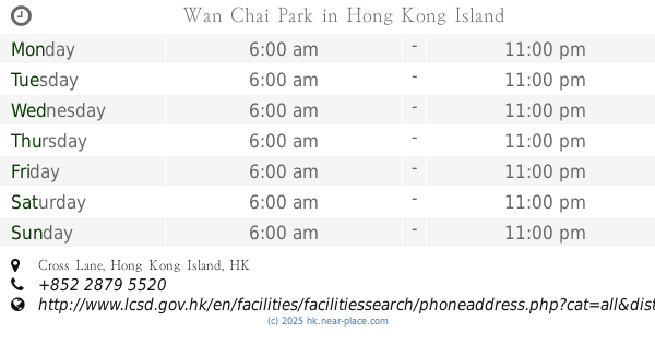
Wan Chai Park
Cross Lane, Wan Chai
Park
read more
814 m
Jockey Club Park
Queen's Road East
Park
read more
819 m
賽馬會復康花園
Wan Chai
Park
read more
850 m
Kennedy Street Sitting-out Area
Near junction of, Kennedy Street
Park
read more
933 m
Stone Nullah Lane Garden
Wan Chai
Park
read more
934 m
Tai Wo Street Playground
Tai Wo Street, Wan Chai
Park
read more
1.087 km
5/F 平台花園
44-50 Lee Tung Street, Wan Chai
Park
read more
1.093 km
五樓平台花園,利東街公共空間
5/F, 30號 Amoy Street, Wan Chai
Park
read more
1.105 km
Green Lane Service Reservoir Sitting-Out Area
Happy Valley
Park
read more
1.164 km
Fleming Road Garden
108 Gloucester Road, Wan Chai
Park
read more
1.211 km
Mount Butler Rest Place
Mount Butler Road, Jardine's Lookout
Park
read more
1.303 km
Ship Street Playground
Wan Chai
Park
read more
1.319 km
Bauhinia Garden
Wan Chai
Park
read more
1.381 km
灣仔峽道休憩處
Wan Chai Green Trail, The Peak
Park
read more
1.41 km
Shui on centre Amarzaya
8 Harbour Road, Wan Chai
Park
read more
📑
all categories
Accounting
Administrative area level 1
Administrative area level 2
Airport
Amusement park
Aquarium
Art gallery
Atm
Bakery
Bank
Bar
Beauty salon
Bicycle store
Book store
Bowling alley
Bus station
Cafe
Campground
Car dealer
Car rental
Car repair
Car wash
Casino
Cemetery
Church
City hall
Clothing store
Colloquial area
Convenience store
Courthouse
Dentist
Department store
Doctor
Electrician
Electronics store
Embassy
Establishment
Finance
Fire station
Florist
Food
Funeral home
Furniture store
Gas station
General contractor
Grocery or supermarket
Gym
Hair care
Hardware store
Health
Hindu Temple
Home goods store
Hospital
Insurance agency
Jewelry store
Laundry
Lawyer
Library
Light rail station
Liquor store
Local government office
Locality
Locksmith
Lodging
Meal delivery
Meal takeaway
Mosque
Movie rental
Movie theater
Moving company
Museum
Natural feature
Neighborhood
Night club
Painter
Park
Parking
Pet store
Pharmacy
Physiotherapist
Place of worship
Plumber
Point of interest
Police
Post office
Premise
Real estate agency
Restaurant
Roofing contractor
Route
Rv park, camping
School
Shoe store
Shopping mall
Spa
Stadium
Storage
Store
Subway station
Supermarket
Synagogue
Taxi stand
Train station
Transit station
Travel agency
University
Veterinary care
Zoo
↑